Journal influence
Higher Attestation Commission (VAK) - К1 quartile
Russian Science Citation Index (RSCI)
Bookmark
Next issue
№1
Publication date:
16 March 2024
Development of algorithm of directed recognition considering information about relief by example of satellite imagery and Earth remote sensing data
The article was published in issue no. № 1, 2014 [ pp. 183-186 ]Abstract: A remote sensing problem concerning unavoidable distortion of the images is researched. It is discovered that if satellite's ground path and distortion mechanism is known, such distortions can be compensated. Additional image adjus t-ment using methods of comparison of control points with geographical map is described. It is mentioned that geographical reference and geometric correction can be combined into one operation of alignment of the details of satellite image and map. The alignment method applied to the image of the reach of the Ural river is given as an example. Directed recognition algo-rithm including information about terrain based on outlining of the image objects is suggested. Differentiation formulas for displacement estimation are provided. The choice of 2-D Laplace operator adjusted to the analysis of satellite images is justi-fied. It is suggested that algorithm speed can be increased with preliminarily worked out block of addresses of image and succeeding operations with addresses of elements resulting 5–8 times higher algorithm speed comparing to direct access to image pixels, that is currently important when processing packets of such high resolution images as satellite images.
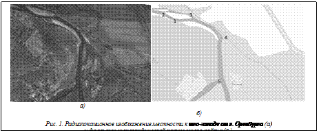
Аннотация:Рассмотрена проблема дистанционного зондирования, заключающаяся в неизбежных искажениях получаемых изображений. Установлено, что такие искажения могут быть скомпенсированы, если известны проекция орбиты спутника на земную поверхность и механизм искажений. Описана дополнительная коррекция снимков методами сопоставления контрольных точек с географической картой. Отмечено, что географическую привязку и геометрическую коррекцию можно объединить в одну операцию совмещения деталей спутникового изображения и карты. Приведен пример совмещения на изображении участка с изгибом реки Урал. Предложен алгоритм направленного распознавания с учетом информации о рельефе, базирующейся на выделении контуров объектов изображения. Приведены формулы дифференцирования, применяемые для расчета смещений, обоснован выбор двухмерных масок оператора Лапласа, наиболее приспособленных для анализа спутниковых снимков. Предложено повышение быстродействия алгоритмов за счет использования предварительно создаваемого массива адресов изображения и последующей работы с адресами элементов. Скорость работы алгоритма повышается в 5–8 раз по сравнению с прямым обращением к пикселям изображения, что актуально для обработки пакетов изображений большого разрешения, таких как спутниковые снимки.
| Authors: Ovechkin M.V. (maxov-1@mail.ru) - Orenburg State University, Orenburg, Russia, Ph.D, Altynbaev R.B. (ravil_djan@mail.ru) - Orenburg State University, Orenburg, Russia, Ph.D, Gafurov A.S. (arturneon@mail.ru) - Orenburg State University, Orenburg, Russia | |
| Keywords: terrain, gps, the allocation of contours, remote sensing, satellite imagery, image, identification |
|
| Page views: 14882 |
Print version Full issue in PDF (7.83Mb) Download the cover in PDF (1.01Мб) |
| Permanent link: http://swsys.ru/index.php?id=3781&lang=en&page=article |
Print version Full issue in PDF (7.83Mb) Download the cover in PDF (1.01Мб) |
| The article was published in issue no. № 1, 2014 [ pp. 183-186 ] |
Perhaps, you might be interested in the following articles of similar topics:
- Применимость программных комплексов для работ со снимками к задаче анализа рентгенограмм
- Использование энтропийных мер в задачах оценки информативности признаков распознавания образов
- Программная реализация системы автоматической идентификации слябов
- Алгоритм определения направления движения локализованных объектов транспортных потоков на цифровых космических снимках
- Настройка и обучение многослойного персептрона для задачи выделения дорожного покрытия на космических снимках города
Back to the list of articles
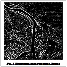
 Важным этапом в процессе подготовки к извлечению признаков изображения является вы- деление краев и контуров объектов на основе подчеркивания перепадов яркости. Выделение вертикальных перепадов осуществляется диф- ференцированием по строкам, горизонтальных – по столбцам. Дифференцирование производится по формулам:
 , (1)
, (1) ,
,

 (2)
(2)


 (2а)
(2а)
